
LPA brings widespread rains across Luzon; emergence and dissipation in WPS possible — PAGASA
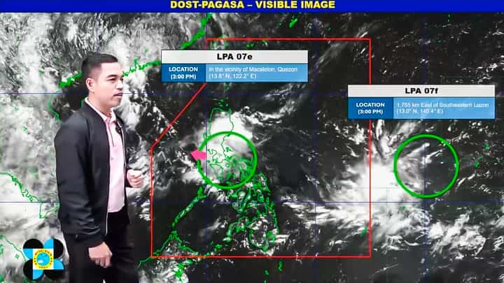
PAGASA Weather Specialist Benison Estareja reporting weather systems inside and outside the Philippine Area of Responsibility (PAR) on Wednesday afternoon, 29 July 2026.
Screenshot from PAGASA 5 PM Weather Update
Luzon experienced scattered rains on Wednesday due to a Low Pressure Area (LPA), which may emerge into the West Philippine Sea or dissipate before moving farther away from land, the Philippine Atmospheric, Geophysical and Astronomical Services Administration (PAGASA) reported.
"This morning, the LPA crossed the Bicol Region, and as of 3 [p.m.] in the afternoon, it was last spotted in the vicinity of the municipality of Macalelon, Quezon Province," PAGASA Weather Specialist Benison Estareja said in the 5:00 p.m. weather update.
"Within the next 12 hours, or later tonight, the weather disturbance is expected to continue moving west-northwest and may emerge into the West Philippine Sea by early tomorrow morning and there is a possibility that it will dissipate before it can move farther away from our landmass," he added.
The Low Pressure Area (LPA 07e), together with the easterlies, brought scattered rains and thunderstorms.
According to Estareja, heavy rainfall may still occur in the coming hours, particularly over Cagayan Valley, La Union, Benguet, Nueva Vizcaya, large parts of Central Luzon, CALABARZON, Metro Manila, the northern portion of MIMAROPA, the Bicol Region, and Panay Island, which may experience a high chance of rain due to the LPA.
The weather forecaster added that the rest of the country, including Southern Palawan, the Visayas, and Mindanao, may experience partly cloudy to cloudy skies with isolated rain showers or thunderstorms due to localized thunderstorms that are not associated with the Low Pressure Area affecting Luzon.
Meanwhile, the state weather bureau reported the formation of another Low Pressure Area (LPA) on Wednesday morning, which was last spotted at 3:00 p.m. approximately 1,755 kilometers east of Southeastern Luzon.
"We also do not see this Low Pressure Area (07f) developing into a tropical cyclone, unlike the LPA that is currently crossing Luzon," Estareja pointed out.
"Based on our latest satellite animation, this LPA also has no direct effect on any part of the country," the weather forecaster added.