
PAGASA: Two LPAs monitored, one may develop into cyclone

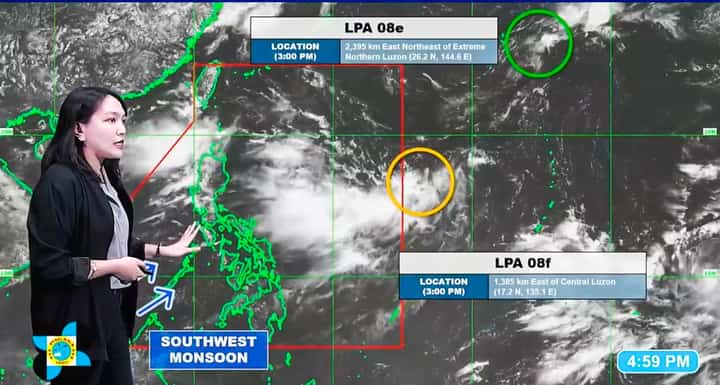
PAGASA Weather Specialist Grace Castañeda-Carpio reported two low-pressure areas (LPAs) being monitored during the 5 p.m. state weather update on Sunday, August 16. Meanwhile, either LPA 08F east of Central Luzon or the developing weather system west of Northern Luzon could potentially develop into a tropical cyclone in the succeeding days.
The Philippine Atmospheric, Geophysical and Astronomical Services Administration (PAGASA) reported that two low-pressure areas (LPAs) were being monitored outside the Philippine Area of Responsibility (PAR) on Sunday.
LPA 08E was last located approximately 2,395 kilometers east-northeast of extreme Northern Luzon, where PAGASA identified the weather disturbance as unlikely to develop into a tropical cyclone and said it is moving away from the PAR.
Meanwhile, another circulation was observed at around 2 p.m. and was designated as LPA 08F, forming from a cloud cluster east of Luzon and the Visayas.
Its latest location was estimated at 1,385 kilometers east of Central Luzon.
“Ngunit mga susunod na mga oras or likely mamayang gabi is papasok na ito sa loob ng PAR,” PAGASA Weather Specialist Grace Castañeda-Carpio said in a 5 p.m. weather update, adding that the LPA is likely to develop into a tropical cyclone in the following days.
(But in the next few hours, or likely tonight, the LPA 08F will enter the PAR.)
Which system will develop into a cyclone?
The weather bureau said LPA 08F could develop into a tropical cyclone as it traverses the waters east of Northern Luzon, while another circulation could form west of Northern Luzon in the succeeding days.
“Either po itong circulation dito sa west ng Northern Luzon or itong si LPA 08f kapag binabaybay na po nito ang karagatan silangan ng Northern Luzon,” Carpio said.
(Either this circulation west of Northern Luzon or LPA 08F, as it traverses the waters east of Northern Luzon.)
PAGASA noted that either of the two systems could potentially develop into a tropical cyclone, while the other may eventually become a trough of the dominant system.
The state weather bureau stressed that the circulation that develops into a cyclone could directly affect Batanes and contribute to the strengthening of the Habagat.