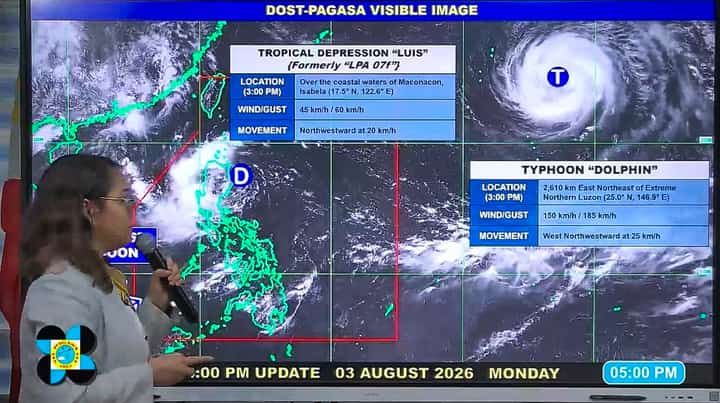
"Tropical Depression Luis has slightly accelerated its movement as it traverses the eastern waters off Isabela," PAGASA Weather Specialist Charmagne Varilla said during 5 p.m. weather update.
The weather disturbance was last monitored at 3 p.m. over the coastal waters of Maconacon, Isabela, packing maximum sustained winds of 45 kilometers per hour (kph) and gusts of up to 60 kph.
"And it continues to move northwestward at 20 kilometers per hour," Varilla said.
Luis is currently affecting the entirety of Northern and Central Luzon, including CALABARZON, the Mindoro provinces, and Marinduque, bringing heavy rains and strong winds.
Meanwhile, the southwest monsoon, or Habagat, is bringing widespread rains, thunderstorms, and gusty conditions over Palawan, Western Visayas, and Negros Occidental.
PAGASA’s latest forecast track showed that the tropical depression is expected to make a close approach or landfall in the area between Cagayan and Isabela on Monday afternoon or evening.
"By tomorrow (Tuesday, August 4), we expect it to remain a tropical depression as it begins to recurve and move northeastward away from the Philippine landmass," Varilla said.
Dolphin monitored outside PAR
The state weather bureau reported that another weather disturbance, a typhoon internationally named “Dolphin”, continues to be monitored outside the Philippine Area of Responsibility (PAR).
The weather disturbance monitored 2610 kilometers east northeast of Extreme Northern Luzon on Monday afternoon, 3 p.m.
Typhoon Dolphin packed maximum sustained winds of 150 kilometers per hour (kph) and gusts of up to 185 kph as it moved west-northwestward at 25 kph.
"We are not ruling out the possibility that it may enter the PAR, but we do not expect it to have any direct effect on any part of the country as it passes over the northern part of Taiwan before eventually making landfall in eastern China," the weather forecaster said.