
PAGASA monitors 3 weather systems outside PAR; Typhoon Dolphin enhances Habagat

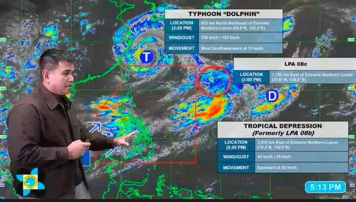
PAGASA Weather Specialist Daniel James Villamil reporting three weather systems outside the Philippine Area of Responsibility during 5 p.m. weather update on 8 August.
Screenshot from PAGASA
The Philippine Atmospheric, Geophysical and Astronomical Services Administration (PAGASA) reported Saturday afternoon that it was monitoring three weather systems outside the Philippine Area of Responsibility (PAR), including Typhoon Dolphin, which is enhancing the southwest monsoon or Habagat and bringing heavy and widespread rains to parts of the country.
“Una, itong typhoon na malapit dito sa northern boundary ng ating PAR na may international name na Dolphin, [na ang] latest location kaning alas tres ng hapon [ay] 825 kilometers north-northeast ng Extreme Northern Luzon,” PAGASA weather specialist Daniel James Villamil said during the agency’s 5 p.m. weather update.
“Itong bagyo na ito ang kasalukuyang nagpapalakas o humahatak ng ating Habagat o southwest monsoon,” he added.
(First, this typhoon near the northern boundary of our PAR, with the international name Dolphin, was last located as of 3 p.m. today at 825 kilometers north-northeast of Extreme Northern Luzon. This typhoon is currently strengthening or pulling our Habagat, or southwest monsoon.)
Latest satellite images from PAGASA showed thick cloud cover over the West Philippine Sea, identified as nimbostratus clouds, which are commonly associated with the Habagat.
According to Villamil, these clouds are affecting most parts of Luzon and the Visayas, as well as the western section of Mindanao.
“Kaya sa mga lugar na ito ay asahan po natin ang malalakas at tuloy-tuloy na mga pag-ulan na ating mararanasan simula ngayong araw hanggang sa araw ng Lunes,” Villamil said.
(So in these areas, we can expect heavy and continuous rains starting today until Monday.)
The state weather bureau advised the public to closely monitor heavy rainfall warnings, particularly in the Ilocos Region, Benguet, Zambales, Bataan, and Occidental Mindoro.
PAGASA, however, forecast generally fair weather over the rest of Mindanao, while cloudy conditions may persist over most parts of Luzon until Wednesday.
Aside from Typhoon Dolphin, PAGASA was also monitoring two other weather disturbances outside the PAR—a tropical depression and a low-pressure area, both located east of Extreme Northern Luzon.
Villamil said the low-pressure area has a moderate chance of developing into a tropical cyclone within the next 24 hours.
“Itong dalawang sama ng panahon na ito ay ang movement po nila ay papalayo sa ating bansa, walang magiging direktang epekto sa lagay ng ating panahon at hindi po ito papasok ng Philippine Area of Responsibility sa mga susunod na araw,” he said.
(These two weather disturbances are moving away from our country, will have no direct effect on our weather conditions, and will not enter the Philippine Area of Responsibility in the coming days.)