
Kiyapo to drench Northern Luzon, strengthen Habagat

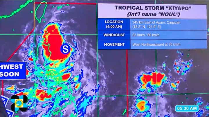
Latest satellite image of Tropical Storm Kiyapo as of 4:00 a.m. Friday, 24 July 2026, 345 kilometers east of Aparri, Cagayan.
Screenshot from PAGASA Weather Update
Tropical Storm Kiyapo (international name: Noul) and the southwest monsoon (Habagat) will bring rains and strong winds across much of the country, particularly Northern Luzon, the Philippine Atmospheric, Geophysical and Astronomical Services Administration (PAGASA) said Friday.
As of 4 a.m., Kiyapo was located about 345 kilometers east of Aparri, Cagayan, packing maximum sustained winds of 65 kph and gusts of up to 80 kph. The storm is expected to make its closest approach to the Babuyan Islands on Friday afternoon.
PAGASA said Northern Luzon, especially Batanes, the Babuyan Islands, and parts of Cagayan, Apayao and Ilocos Norte, will experience cloudy skies with scattered rains, thunderstorms and gusty winds.
Tropical Cyclone Wind Signal No. 2 remains hoisted over Batanes, the Babuyan Islands, the northern portion of mainland Cagayan, and northern Ilocos Norte, while Signal No. 1 is in effect over the rest of mainland Cagayan, Isabela, Nueva Vizcaya, Quirino and parts of the Cordillera and Ilocos regions.
PAGASA also warned that Habagat and Kiyapo's outer circulation will bring strong to gale-force winds over much of Luzon and the Visayas through Saturday, with strong monsoon winds expected over parts of western Luzon on Sunday.