
LPA outside PAR highly likely to become tropical depression today
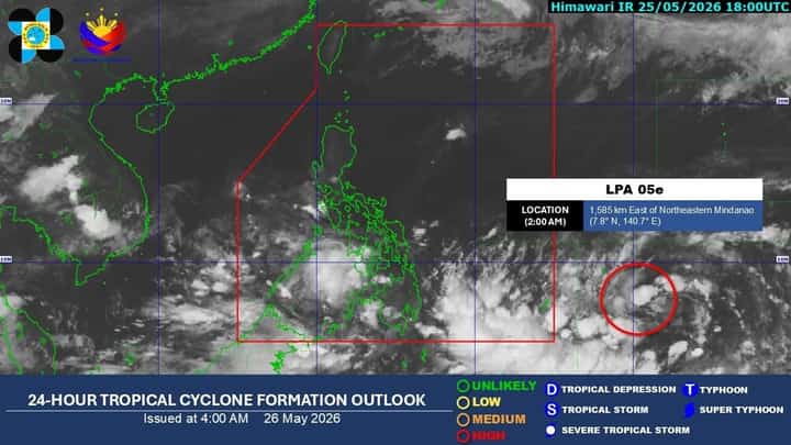
24-Hour Tropical Cyclone Formation Outlook issued by PAGASA at 4 a.m., 26 May 2026. LPA 05e has now been elevated to "HIGH" likelihood of intensifying to a tropical depression within the next 24-48 hours, PAGASA reported Tuesday morning.
Image from DOST-PAGASA
The low-pressure area (LPA) monitored outside the Philippine Area of Responsibility (PAR) has now been elevated into having a "high" likelihood of becoming a tropical depression within the next 24 to 48 hours, the Philippine Atmospheric, Geophysical and Astronomical Services Administration (PAGASA) reported Tuesday.
As of 2 a.m., the weather disturbance, labeled LPA 05e, was last located 1,585 kilometers east of Northeastern Mindanao outside the Philippine Area of Responsibility. It moves west-northwest and is expected to enter PAR by Friday or Saturday, where it will be given the name "Domeng" when it arrives as a tropical depression.
Despite its distance from the Philippine landmass, the LPA's trough or extension continues to bring moderate to heavy rains to the southern and eastern regions of Mindanao, while southwesterly winds bring precipitation to the western regions of Mindanao as well as Palawan. The continuous downpours caused waterways to flood several barangays in North Cotabato and displaced over 200 families in Zamboanga, according to the Department of Social Welfare and Development's (DSWD) Disaster Response Operations Management, Information and Communication (DROMIC) report on Monday.
Meanwhile, Metro Manila and the rest of the country may experience cloudy to partly cloudy weather with chances of localized thunderstorms in the afternoon and evening, said the state weather bureau.