
PAGASA raises cyclone potential of Mindanao LPA
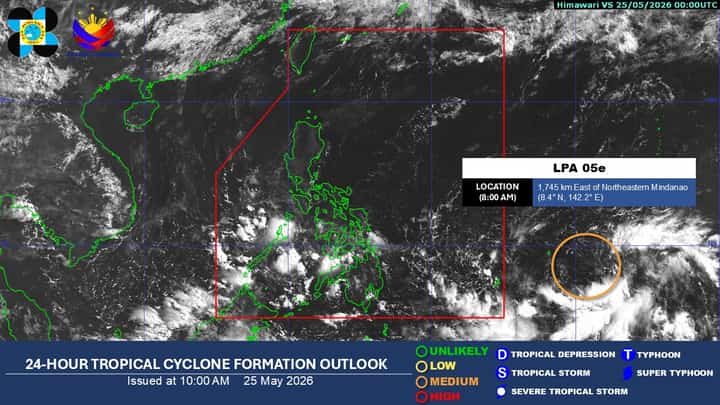
24-hour Tropical Cyclone Formation Outlook issued by PAGASA on 10 A.M., 25 May 2026. LPA 05e, monitored outside the Philippine Area of Responsibility, was elevated into "MEDIUM" likelihood of becoming a tropical cyclone as is to possibly intensify into a tropical depression by Tuesday or Wednesday. It is expected to enter PAR by the end of the week, and will be given the name "Domeng" as it enters Philippine waters.
Image from DOST-PAGASA
A low-pressure area east of Mindanao now has a medium chance of developing into a tropical depression within 24 hours, according to the Philippine Atmospheric, Geophysical and Astronomical Services Administration on Monday.
As of 8 a.m., the weather system identified as LPA 05e was located 1,745 kilometers east of northeastern Mindanao, still outside the Philippine Area of Responsibility.
PAGASA said the trough of the weather disturbance is bringing cloudy skies, scattered rain showers, and thunderstorms over Palawan and the entire Mindanao region.
The likelihood of the system intensifying into a tropical cyclone was upgraded after days of monitoring over the Pacific Ocean.
State meteorologists initially tracked the disturbance over the weekend when it was around 2,000 kilometers east of northeastern Mindanao and carried only a low probability of developing into a typhoon.
As the system moved westward to its current position, forecasters raised its development potential to a medium likelihood.
PAGASA said the weather disturbance may intensify into a tropical depression by Tuesday or Wednesday and could enter PAR by Friday or Saturday.
Once inside PAR, the system will be assigned the local name “Domeng” under PAGASA’s tropical cyclone naming system.
Meanwhile, extreme heat continues to affect large parts of the country.
The weather bureau warned that 44 areas may experience “danger” level heat indices on Monday, with apparent temperatures expected to reach as high as 47 degrees Celsius in Dagupan City, Aparri, and the Science City of Muñoz.
Actual temperatures are also expected to remain high, with Metro Manila forecast to experience temperatures between 26 and 35 degrees Celsius, while Tuguegarao City could reach up to 37 degrees Celsius.
Baguio City remains the coolest area with temperatures ranging from 19 to 26 degrees Celsius.
PAGASA added that prevailing easterlies will continue bringing partly cloudy to cloudy skies with isolated rain showers over the Bicol Region and Quezon province, while Metro Manila and the rest of the country may experience localized afternoon or evening thunderstorms.
Forecasters also projected that a southwesterly windflow may begin prevailing by Tuesday or Wednesday, bringing scattered rains and thunderstorms over the Zamboanga Peninsula, the Bangsamoro Autonomous Region in Muslim Mindanao, and Palawan.
The shift is considered an indication of the approaching rainy season, which PAGASA expects to officially declare by late May or early June once rainfall criteria are met.