




Suspect pinpointed in Sandy Cay rape
China Coast Guard and Chinese Maritime Militia vessels are frequently observed swarming the cays.

Text size
China Coast Guard and Chinese Maritime Militia vessels are frequently observed swarming the cays.
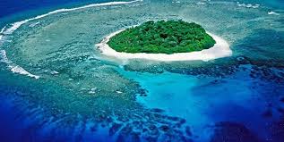
Marine biodiversity center Sandy Cay in the West Philippine Sea (WPS) is now in a “degraded state” due to overfishing, the impact of climate change, and China’s island-building activities, an expert said on Saturday.
In a news forum, marine scientist Dr. Jonathan Anticamara painted a concerning picture of the marine biodiversity surrounding Sandy Cay.
Sandy Cay is adjacent to Pag-asa Island which is situated in the municipality of Kalayaan in the West Philippine Sea.
“Pag-asa cays have less than 10 coral and fish species per 100-square meter transect that we surveyed, and most (of) the observed corals and fish species are small in size,” Anticámara said during the presentation of his team’s assessment.
Incriminating evidence
Commodore Jay Tarriela, spokesperson for the National Task Force for the WPS, attributed the “degradation” of Sandy Cay to China.
“If you are going to ask me now who is our suspect in doing these illegal small island reclamations in Cays 1,2,3,4, there’s no other country that we can pinpoint — it’s only the People’s Republic of China,” Tarriela said.
He said that although Anticamara’s findings did not explicitly identify China as the party responsible for dumping dead corals in the cay and carrying out small-scale island reclamation, only China has access to these cays, which are located near its reclaimed military base on Subi Reef.
“Additionally, the China Coast Guard and Chinese Maritime Militia have been frequently observed swarming the cays,” he said on social media.
He said that China has imposed restrictions on the Philippine survey team, hindering the completion of its work.
“During our exploration, there were no other countries’ vessels sailing in the vicinity waters off Sandy Cay. Our embedded media personnel can confirm the absence of Vietnamese, Malaysian, or Indonesian-flagged vessels,” according to Anticamara.
“Many of the corals here on this island, including Pag-asa Island itself and the cays, are now degraded. By degraded, I mean that many of the corals are now small, a lot of the large corals are dead, and there’s not a lot of live corals per unit area anymore, so there are very few remaining,” he said.
Anticamara said the coral rubble on Pag-asa Cays 1, 2 and 3 can be seen during high tide, where the debris are dumped on large live coral colonies.
In September 2023, experts discovered deceased and fragmented corals on Sandy Cay 2, a practice reportedly typical of China prior to initiating land reclamation.
“The pile of sand and rubble on Pag-asa Cays 1, 2 and 3 have many characteristics that are atypical of naturally formed coral or sandy barrier islands, indicating that these are possibly products of island building activities that are observed in the WPS, but with some degree of uncertainty,” Anticamara said.
In March, a group of Filipino marine scientists sustained injuries following harassment by a Chinese Navy helicopter near Sandy Cay.
The helicopter flew at a low altitude over the merging sandbars and the scientists for 10 minutes.
The turbulence generated by the helicopter blades dispersed the deceased corals, resulting in cuts and scratches to the Filipino researchers.
China asserts sovereignty over nearly the entire South China Sea, a vital route for over $3 trillion in annual maritime trade, encompassing territories also claimed by the Philippines, Vietnam, Indonesia, Malaysia and Brunei.
Certain areas within the Philippines’ exclusive economic zone have been designated as the West Philippine Sea.
In 2016, an international arbitration tribunal in The Hague ruled that China’s claims lacked legal justification. Beijing dismissed the verdict.
Buddies, associates? One happy family?
A traditional dish called zongzi is served during China’s Dragon Boat Festival, which falls in June. It is a rice…
Divina credited the firm’s achievements to its members, thanking them for their ‘hard work, dedication, teamwork, and…
‘Sec. Vince Dizon, please explain how this finding of your own team should not be flagged as a ghost project in Taguig.’
