- NEWS
- the EDIT
- COMMENTARY
- BUSINESS
- LIFE
- SHOW
- ACTION
- GLOBAL GOALS
- SNAPS
- DYARYO TIRADA
- MORE

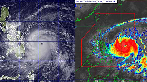
As Typhoon #UwanPH, internationally known as Fung-Wong, enters the Philippine Area of Responsibility, satellite imagery and advisories from the Philippine Atmospheric, Geophysical and Astronomical Services Administration (PAGASA) show a stark contrast when compared to Typhoon Yolanda, one of the deadliest storms in the country’s history.
While Yolanda appeared smaller on satellite images, it was an extremely powerful cyclone, packing sustained winds of up to 315 kilometers per hour and a central pressure of 895 hPa. Its compact yet intense core generated catastrophic storm surges—some reaching up to five meters—which inundated coastal communities in Eastern Visayas.
Yolanda left more than 6,300 people dead and displaced over four million, marking it as one of the most devastating natural disasters in the Philippines’ recent history.
Uwan, by contrast, is physically much larger in diameter. PAGASA reports that its strong wind radius extends up to 780 kilometers from the center, making its circulation wide enough to influence weather across large portions of the archipelago.
Initial data show sustained winds of 110 kph, with gusts of up to 135 kph, though forecasts indicate that Uwan may intensify to typhoon strength, potentially reaching up to 185 kph as it approaches Northern and Central Luzon.
The comparison highlights a critical concept in tropical cyclone science: size does not directly determine destructive strength. Yolanda’s smaller footprint delivered catastrophic localized impact due to extreme wind intensities and storm surge. Uwan’s wider structure may generate broader—but potentially less concentrated—impacts, including widespread heavy rain, flooding, and storm surges across multiple regions.
PAGASA estimates that at least 8.4 million people may be affected as Uwan moves across the Visayas and northern Luzon. Local governments have begun implementing preemptive preparations, including evacuation planning and reinforcement of flood-prone zones.
While Uwan may not match Yolanda’s peak wind intensity, its expansive circulation, rainfall potential, and storm surge risks remain serious concerns. Authorities urge the public to monitor official advisories, prepare essential supplies, and follow evacuation orders when issued.
Both storms underscore the Philippines’ high vulnerability to tropical cyclones—but in different ways: Yolanda demonstrated how a compact storm can cause overwhelming destruction, while Uwan shows how a large-scale system can threaten millions across a wide geographic area.
