- NEWS
- the EDIT
- COMMENTARY
- BUSINESS
- LIFE
- SHOW
- ACTION
- GLOBAL GOALS
- SNAPS
- DYARYO TIRADA
- MORE

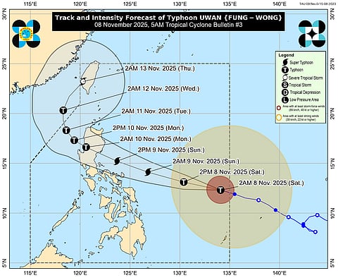
Typhoon Uwan has further intensified while moving west-northwestward over the sea east of Eastern Visayas, bringing the threat of destructive winds, torrential rain, and dangerous sea conditions across parts of Luzon and Visayas, the Philippine Atmospheric, Geophysical and Astronomical Services Administration (PAGASA) said in its latest advisory.
Uwan is expected to rapidly strengthen into a super typhoon tonight or by Sunday morning (November 9) and may make landfall at or near its peak intensity over the southern portion of Isabela or northern Aurora late Sunday evening or early Monday morning (November 10). After crossing the mountainous terrain of Northern Luzon, the typhoon is projected to emerge over the West Philippine Sea by Monday morning or afternoon.
While the core of Uwan has yet to make landfall, PAGASA warned that heavy rainfall, destructive winds, and storm surges may be felt even in areas outside the forecast landfall point due to the cyclone’s wide circulation.
Tropical Cyclone Wind Signals (TCWS) remain in effect, with PAGASA warning that the highest possible signal to be raised is Signal No. 5 during Uwan’s passage.
Signal No. 2 areas may experience minor to moderate impacts from gale-force winds, while Signal No. 1 areas could face minimal to minor impacts from strong winds.
Uwan will also bring occasional gusty conditions reaching strong to gale-force strength over Palawan, Visayas, and Mindanao today and Sunday, and over Luzon and Visayas by Monday.
PAGASA raised a high risk of life-threatening storm surges exceeding three meters along coastal areas of Isabela, Aurora, Quezon (including Polillo Islands), Camarines Norte, Camarines Sur, Catanduanes, Albay, Sorsogon, Northern Samar, and Eastern Samar within the next 48 hours.
Residents in these low-lying and coastal areas are strongly advised to move to higher ground and coordinate with local disaster officials.
A Gale Warning is in effect for the northern and eastern seaboards of Luzon and the eastern seaboard of Visayas, with sea conditions reaching up to 14 meters high in some areas.
Very rough to phenomenal seas (6–14 meters) are expected over the eastern seaboards of Catanduanes, Camarines Sur, Albay, Sorsogon, Northern Samar, Aurora, and Quezon, as well as the Polillo Islands.
Rough to very rough seas (3–7 meters) will prevail over parts of Ilocos, Zambales, Davao Oriental, and other coastal provinces.
Moderate to rough seas (2–4 meters) are expected in Visayas, Mindanao, and parts of southern Luzon.
Sea travel remains risky for all types of vessels, and PAGASA advised all mariners to stay in port or seek shelter until conditions improve.
PAGASA emphasized that Uwan’s track and intensity may still change within the forecast confidence cone, but its overall threat remains high. Heavy rainfall, severe winds, and storm surges are expected to intensify as the system nears landfall.
Residents in Northern and Central Luzon, as well as eastern coastal provinces of Visayas and Bicol, are urged to closely monitor official forecasts and advisories, stay alert for emergency warnings, and coordinate with local authorities for possible evacuations.
