- NEWS
- the EDIT
- COMMENTARY
- BUSINESS
- LIFE
- SHOW
- ACTION
- GLOBAL GOALS
- SNAPS
- DYARYO TIRADA
- MORE

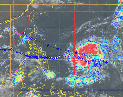
The Philippine Atmospheric, Geophysical and Astronomical Services Administration (PAGASA) on Friday upgraded Typhoon Fung-Wong — to be locally named Uwan once it enters the Philippine Area of Responsibility (PAR) — into a severe tropical storm as it continues to move northwestward over the Pacific Ocean.
As of 11 a.m., the storm’s center was estimated at 1,500 km east of Northeastern Mindanao or 1,470 km east of Eastern Visayas (outside PAR). It currently packs maximum sustained winds of 95 km/h near the center and gustiness of up to 115 km/h, moving northwest at 10 km/h.
PAGASA said Fung-Wong is expected to enter PAR by midnight or early Saturday morning, after which it will be given the local name Uwan. The weather bureau added that the system may rapidly intensify into a typhoon within 24 hours and could reach super typhoon status by Saturday evening or Sunday morning.
Under the current forecast, Uwan also has the potential to make landfall over Northern or Central Luzon on Monday at or near its peak intensity.
Tropical Cyclone Wind Signals (TCWS) may be raised over the eastern portions of Luzon and Samar provinces as early as Friday afternoon or Saturday morning, with Signal No. 5 as the highest possible alert level.
PAGASA warned that weather conditions may deteriorate by Sunday, bringing widespread heavy rains and stormy conditions over Northern and Central Luzon by Monday and Tuesday.
Moderate to rough seas are expected over the northern and eastern seaboards of Luzon and the eastern seaboards of Visayas and Mindanao starting Friday or Saturday, while very rough to phenomenal seas may prevail over most of Luzon and eastern Visayas from Sunday onwards.
PAGASA urged the public, local government units, and disaster risk reduction offices to monitor official updates and prepare for possible severe weather conditions.
