- NEWS
- the EDIT
- COMMENTARY
- BUSINESS
- LIFE
- SHOW
- ACTION
- GLOBAL GOALS
- SNAPS
- DYARYO TIRADA
- MORE

TACLOBAN CITY — Under a blazing sun, thousands of residents visited cemeteries here on the two-day “Undas” holiday to pay respects to their departed loved ones. But amid the heat and the hum of prayers, unease was in the air.
“This weather reminds me exactly of Yolanda,” said 42-year-old Lorna, lighting candles at the mass grave for victims of super typhoon "Yolanda." “The day before it hit, the weather was fine — just like this. We never expected how strong it would be.”
A decade after the 2013 disaster, residents are now on edge as typhoon "Tino" — seen to follow a similar path — moves closer to the region. Online warnings dubbing it “Yolanda Junior” have spread quickly, prompting local governments and schools to issue precautionary measures.
As of Sunday morning, the Philippine Atmospheric, Geophysical, and Astronomical Services Administration (PAGASA) placed the whole of Eastern Samar under Signal No. 1, with Tino’s center estimated at 955 kilometers east of Eastern Visayas. The system packs maximum sustained winds of 85 km/h and gustiness of up to 105 km/h, with forecasts showing continued strengthening as it nears land.
Several schools, including Eastern Visayas State University, Leyte Normal University and UP Tacloban, have suspended face-to-face classes on 3 and 4 November and will shift to online learning.
Meanwhile, the Regional Disaster Risk Reduction and Management Council (RDRRMC) has urged the public to defer non-essential travel to and from the region to avoid stranded passengers and logistical disruptions in ports, terminals and road networks.
Lorna said her family has already begun preparing: “We were caught unprepared during Yolanda. This time, we’ve wrapped our clothes and documents in plastic. We won’t let that happen again.”
Cagayan de Oro on alert
In Cagayan de Oro City, local officials are also bracing for Tino’s impact. The City Disaster Risk Reduction and Management Department, led by Nick Jabagat, held a virtual pre-disaster risk assessment meeting on Saturday to align the city and barangays’ response plans.
The meeting was attended by DILG City Director Ellaine Josephine Depaur, Mayor Rolando “Klarex” Uy’s Chief of Staff Sheila Lumbatan, and representatives from the City Social Welfare and Development Office and City Information Office.
According to the latest PAGASA bulletin, "Tino" is expected to enter the Philippine Area of Responsibility through the Caraga or Northern Mindanao region.
Jabagat said barangay disaster committees have begun “scenario-building” exercises and preparations, including: Activation of BDRRMCs, readiness of evacuation centers and response facilities, clearing of drainage systems and canals, and 24/7 patrols in flood- and landslide-prone areas.
“Residents, especially in the hinterland barangays, should be alert for possible landslides and flash floods,” Jabagat warned.
Heavy equipment and response teams are now on standby, as authorities urge the public to stay tuned to official weather advisories and remain vigilant.
DSWD on full alert
Meanwhile, the Department of Social Welfare and Development (DSWD) assured the public that all its field offices are on full alert.
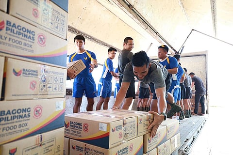
Under the Bagong Bansa Handa program, the DSWD has prepositioned relief goods nationwide using a dual supply chain system involving both government and private partners.
“We strengthened the production and stockpiling of family food packs (FFPs) by adding more warehouses and partnering with LGUs,” said DSWD spokesperson Assistant Secretary Dumlao. “We also work with private distributors so we can quickly add supplies when needed.”
Through its mechanized and manual packing systems in Luzon and Visayas, DSWD can now produce 18,000 to 20,000 FFPs per day, ensuring faster replenishment and deployment of aid.
As of now, 558,098 food packs are prepositioned nationwide — including 122,884 in MIMAROPA, 89,566 in Western Visayas, 70,799 in the Negros Island Region, 71,539 in Central Visayas, 121,331 in Eastern Visayas, and 81,989 in CARAGA.
The agency also readied its mobile command center, kitchen units, and water trucks to support evacuees.
DSWD’s Disaster Response Management Bureau remains on high alert for Undas and continues to monitor another low-pressure area outside PAR that could develop into a cyclone.
The public is advised to stay vigilant, follow official advisories, and cooperate with authorities to ensure a safe Undas 2025.
