- NEWS
- the EDIT
- COMMENTARY
- BUSINESS
- LIFE
- SHOW
- ACTION
- GLOBAL GOALS
- SNAPS
- DYARYO TIRADA
- MORE

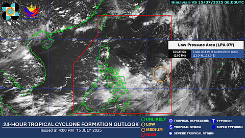
The cloud cluster over the Philippine Sea has developed into a low-pressure area and has a “medium” chance of strengthening into a tropical depression within the next 24 hours.
As of 2:00 PM Tuesday, PAGASA last spotted the low-pressure area 1,040 kilometers east of southeastern Luzon.
Weather Specialist Veronica Torres said the low-pressure area could intensify into a tropical depression by late Wednesday to early Thursday.
Once it strengthens, it will be given the local name "Crising", the third tropical cyclone to enter the country this year.
Cloudy skies with scattered rains and thunderstorms are expected over Caraga, Eastern Visayas, and parts of the Bicol Region due to the low-pressure area.
Moderate to heavy rains, ranging from 50 to 100 millimeters, are forecast on Wednesday in the provinces of Antique, Negros Occidental, Negros Oriental, Northern Samar, and Eastern Samar due to the combined effects of the low-pressure area and the southwest monsoon.
The southwest monsoon is also bringing scattered rains and thunderstorms over Metro Manila, Calabarzon, Mimaropa, and the rest of Visayas and Mindanao.
PAGASA warned of possible flash floods and landslides due to anticipated moderate to heavy rainfall.
Moderate sea conditions are expected over the West Philippine Sea and extreme northern Luzon, while light to moderate conditions are forecast over the Philippine Sea.
