- NEWS
- the EDIT
- COMMENTARY
- BUSINESS
- LIFE
- SHOW
- ACTION
- GLOBAL GOALS
- SNAPS
- DYARYO TIRADA
- MORE

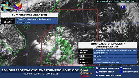
A low-pressure area has developed over the waters off Iba, Zambales, but it has a low chance of developing into a tropical depression within the next 24 hours, PAGASA said Monday.
As of 3:00 PM, the state weather bureau located the low-pressure area 175 kilometers west-southwest of Iba, Zambales.
Outside the Philippine Area of Responsibility, Tropical Storm “Sepat” was spotted approximately 2,315 kilometers east-northeast of Extreme Northern Luzon. The storm is moving north-northwestward at 30 kilometers per hour and is not expected to enter the PAR.
Zambales, Bataan, and Pangasinan are expected to experience rain due to the combined effects of the low-pressure area and the southwest monsoon.
PAGASA weather specialist Rhea Torres said the southwest monsoon is also bringing cloudy skies and scattered rains over Metro Manila, Calabarzon, Mimaropa, the Bicol Region, Central Visayas, the Zamboanga Peninsula, and the Bangsamoro Autonomous Region.
Rainy conditions in Metro Manila are expected to continue until Thursday, with possible weather improvements by Friday.
Light to moderate sea conditions are expected over the country’s open waters.
