- NEWS
- the EDIT
- COMMENTARY
- BUSINESS
- LIFE
- SHOW
- ACTION
- GLOBAL GOALS
- SNAPS
- DYARYO TIRADA
- MORE

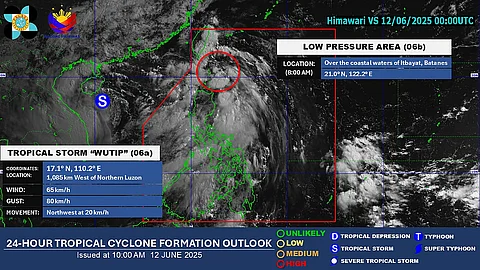
A low-pressure area (LPA) with a “high” chance of developing into a tropical cyclone in the next 24 hours was last spotted over the coastal waters of Itbayat, Batanes.
Once it strengthens into a tropical cyclone while still within the Philippine Area of Responsibility, it will be given the local name “Auring” — the first tropical cyclone of 2025.
Philippine Atmospheric, Geophysical and Astronomical Services Administration (PAGASA) weather forecaster John Manalo said in a phone interview that the said weather system is forecasted to move in a northwestward direction towards Taiwan.
“So far as the LPA moves to Taiwan, it is currently directly affecting the Batanes and Cagayan region.”
As of 11 a.m. on Thursday, Zambales is placed under a heavy rainfall warning due to the southwest monsoon.
Manalo said that starting on Friday, the southwest monsoon is expected to start to weaken, and that the amount of rains may start to lessen.
In Zamboanga del Norte, which was experiencing continuous rain over the past days due to the southwest monsoon, a spillway in the town of Sibuco is impassable due to the heavy water flow.
Manalo noted that the rains are caused by the southwest monsoon, which was also accompanied by the local thunderstorms.
Based on the 24-hour-rainfall forecast issued by PAGASA, rainfall of at least 50 to 100 millimeters are expected over Batanes, Cagayan, Pangasinan, Zambales, Bataan and Occidental Mindoro until this Friday afternoon.
Aside from the southwest monsoon, the low-pressure area and tropical storm “Wutip” which is approaching Hainan Island-Vietnam area, the PAGASA said that there are no other cloud clusters or low pressure areas being monitored within the Philippine Area of Responsibility.
There are no gale warnings raised, however, moderate to rough sea conditions are expected within the seaboards of Northern Luzon, including Batanes, western section of Luzon, and western section of Palawan.
