- NEWS
- the EDIT
- COMMENTARY
- BUSINESS
- LIFE
- SHOW
- ACTION
- GLOBAL GOALS
- SNAPS
- DYARYO TIRADA
- MORE

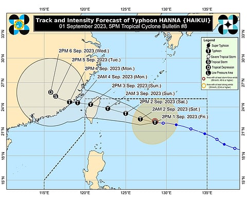
Typhoon "Hanna" maintains strength as it decelerates westward but is "less likely to directly" bring heavy rains, rough seas conditions, and severe winds over the country throughout the forecast period, the Philippine Atmospheric, Geophysical and Astronomical Services Administration said Friday.
However, PAGASA said the southwest monsoon or "habagat" currently enhanced by "Hanna" and Typhoon "Saola" (formerly "Goring"), and Severe Tropical Storm "Kirogi" will bring occasional monsoon rains over the western portion of Luzon in the next three days. It will also cause gusty conditions over the following areas not under any Wind Signal, especially in coastal and upland/mountainous areas exposed to winds in Batanes, Ilocos Region, Abra, Benguet, Zambales, Bataan, Bulacan, Aurora, Metro Manila, CALABARZON, MIMAROPA, Bicol Region, Western Visayas, and the northern portion of Eastern Visayas until Saturday.
PAGASA said similar weather conditions will be experienced over the Batanes, Ilocos Norte, Ilocos Sur, Zambales, Bataan, Bulacan, Aurora, Metro Manila, CALABARZON, MIMAROPA, Bicol Region, and Western Visayas on Sunday.
Also, Typhoon "Hanna" is less likely to bring rough sea conditions over any seaboard of the country through the forecast period.
However, due to the southwest monsoon that is slightly enhancing, a Gale Warning is in effect for most seaboard of Luzon and Western Visayas, and the seaboard of Northern Samar.
"Hanna" is forecast to move generally west-northwestward throughout the forecast period. It may pass close to or make landfall in the vicinity of the Yaeyama Islands in the Ryukyu archipelago between tomorrow evening and Sunday morning.
Then make landfall on Sunday morning and traverse over Taiwan.
"Hanna" is forecast to exit the Philippine Area of Responsibility on Sunday afternoon or evening.
PAGASA said the tropical cyclone will turn more westward as it passes over the Taiwan Strait before making another landfall over mainland China on Monday morning or afternoon when outside PAR.
Meanwhile, "Hanna" may reach its peak intensity on Sunday morning prior to its landfall over Taiwan while its rapid weakening will then ensue following its landfall over mainland China on Monday.
"Hanna" was last tracked over 710 kilometers East Northeast of Itbayat, Batanes, packing maximum sustained winds of 120 kilometers per hour near the center and gustiness of up to 150 kph while moving westward at 15 kph.
