- NEWS
- the EDIT
- COMMENTARY
- BUSINESS
- LIFE
- SHOW
- ACTION
- GLOBAL GOALS
- SNAPS
- DYARYO TIRADA
- MORE

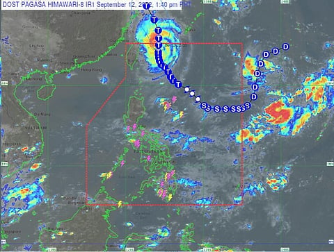
The Typhoon "Inday" further weakens as it approaches the Ishigaki Island of Southern Japan, according to the state weather bureau on Monday, 12 September.
In its latest weather advisory, the Philippine Atmospheric, Geophysical and Astronomical Services Administration ruled out the pouring of heavy rains and hoisting Tropical Cyclone Wind Signals throughout the forecast period.
It added that gusty conditions reaching strong-to-gale force strength may be experienced over Extreme Northern Luzon today through Wednesday due to the channeling of the typhoon circulation in the Luzon Strait.
Meanwhile, a gale warning remains in effect n the seaboards of Batanes and Babuyan Islands.
Inday may also bring moderate to rough seas over the eastern seaboard and the remaining northern seaboard of Northern Luzon (1.2 to 3.0 m) until Tuesday.
The typhoon, which was last spotted 65 km North Northeast of Itbayat, Batanes moving towards the vicinity of Yaeyama Islands, will exit the Philippine area of responsibility Monday night.
Inday will turn more north-northwestward over the East China Sea while gradually accelerating outside the PAR.
It is forecast to gradually weaken throughout the forecast period due to the cooler waters over sea east of Taiwan, resulting from upwelling brought on by the slow movement of the typhoon, and the East China Sea.
It increases vertical wind shear along its projected path.
Meanwhile, PAGASA weather specialist Obet Bradina said they are now monitoring the movement of a low-pressure area, which already turns into a tropical depression and was last tracked over 1,815 kilometers north extreme of Northern Luzon.
Bradina noted the tropical depression will likely enter the PAR by Tuesday.
It will be called storm "Josie" once it enters the PAR, but it is not expected to directly affect the country.
