- NEWS
- the EDIT
- COMMENTARY
- BUSINESS
- LIFE
- SHOW
- ACTION
- GLOBAL GOALS
- SNAPS
- DYARYO TIRADA
- MORE

As communities across northern Luzon brace for Super Typhoon Nando, the approaching storm has already triggered evacuations, heightened warnings, and rekindled frustrations over corruption in flood control projects.
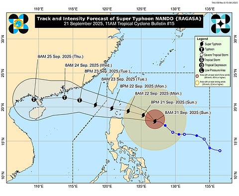
Nando, described by PAGASA as undergoing "rapid intensification," is forecast to strike near the Batanes or Babuyan islands by Tuesday afternoon. With maximum sustained winds at 185 kilometers per hour and gusts peaking at 230 kph, the storm is shaping up to be one of the strongest weather systems to threaten the region this year.
Interior Secretary Jonvic Remulla urged local governments to act quickly. "Local officials must waste no time in moving families out of danger zones," he said in a statement.
The storm’s trajectory also has Taiwan on edge. Officials there confirmed nearly 300 people would be moved from vulnerable communities in Hualien County. "We estimate that a land typhoon warning will be issued tonight... and tomorrow morning at 6 am the typhoon will approach Taiwan’s offshore," Taiwan’s Central Weather Administration reported.
In a press briefing, Philippine weather specialist John Grender Almario warned of potentially devastating conditions. "Severe flooding and landslides" are expected in northern Luzon, with the strongest impacts forecast to hit by Monday morning. "We expect that the effects of the super typhoon will be felt beginning tonight," Almario added.
While Manila is predicted to avoid the worst of Nando, the capital was already the scene of storm-related unrest. Thousands gathered Sunday to denounce billions lost in incomplete or fraudulent flood control projects, demanding accountability as another disaster loomed.
The Philippines, lying in the Pacific cyclone belt, is no stranger to such threats. With an average of 20 storms every year, entire communities live under constant risk. Scientists warn that warming seas caused by human-driven climate change are supercharging these storms, making them more destructive with each passing decade.
Hong Kong authorities also began issuing warnings, noting that weather would "deteriorate gradually" on Tuesday and Wednesday. The Hong Kong Observatory cautioned that gale-force winds and storm surge levels could mirror those of Typhoon Mangkhut in 2018, which left a costly trail of destruction.
As of the latest advisory, PAGASA raised Signal No. 2 in Batanes, the Babuyan Islands, parts of Cagayan, Isabela, Apayao, Kalinga, and Ilocos Norte. Areas under Signal No. 1 include the rest of Isabela, Quirino, Nueva Vizcaya, the Cordillera provinces, Ilocos Sur, La Union, Pangasinan, Zambales, Nueva Ecija, Tarlac, and Aurora.
