- NEWS
- the EDIT
- COMMENTARY
- BUSINESS
- LIFE
- SHOW
- ACTION
- GLOBAL GOALS
- SNAPS
- DYARYO TIRADA
- MORE

Flooding remains a serious threat in many parts of Metro Manila during heavy rains. This is especially true in areas around the Marikina River. When water levels rise, the risk of flooding increases not just in Marikina City but in other low-lying areas across the metro.
The Marikina River begins in the mountains of Rodriguez, Rizal, flowing past the historic Wawa Dam and into San Mateo, then Marikina City, before meeting the Pasig River. A critical junction point is the Manggahan Floodway in Pasig, which helps divert excess water to Laguna de Bay during intense storms.
Major disasters in recent memory include Typhoon Ondoy (Ketsana) in 2009, which caused record flooding that displaced nearly half a million people, and the 2012 southwest monsoon rains enhanced by Typhoon Haikui, which pushed the river beyond its danger level. These events prompted improvements in flood control, drainage systems, and early warning mechanisms.
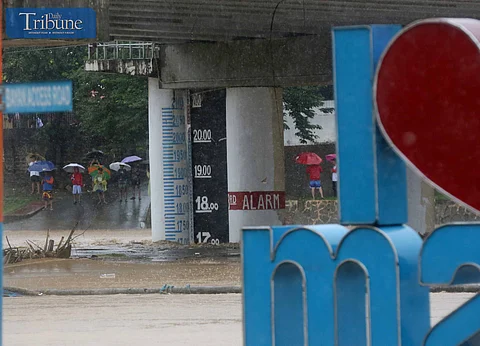
Today, Marikina City uses a three-level alarm system based on the river's depth below the Sto. Niño Bridge to warn residents of dangerous flooding:
Alarm Level 1 (15m) – Prepare
Alarm Level 2 (16m) – Evacuate
Alarm Level 3 (18m) – Forced Evacuation
For verified and real-time updates, visit Daily Tribune’s website and social media pages. You can also follow Marikina City Rescue 161 on Facebook for livestream monitoring of the river and alerts, as well as Marikina PIO for information on rescue and relief efforts.
