- NEWS
- the EDIT
- COMMENTARY
- BUSINESS
- LIFE
- SHOW
- ACTION
- GLOBAL GOALS
- SNAPS
- DYARYO TIRADA
- MORE

The difference between being stranded and staying safe? Sometimes, it’s just knowing where not to go.
Now more than ever, as flash floods become more frequent and unpredictable, even reaching areas once thought immune like exclusive subdivisions, major highways, and urban centers, Project NOAH proves itself an indispensable tool for every Filipino trying to stay one step ahead of the rain.
Launched in 2012 and now under the University of the Philippines, Project NOAH (Nationwide Operational Assessment of Hazards) is the country’s premier disaster information system. Its mission is simple: give everyone from local officials to regular commuters real-time hazard data, and make it accessible, accurate, and actionable.
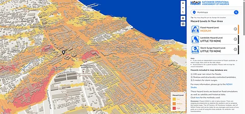
With just a phone or internet connection, you can check whether the roads around you are flooded, which areas are under heavy rainfall, or if a nearby river is rising.
The NOAH mobile app and web portal deliver near real-time updates on weather systems, flood hazards, rainfall intensities, and landslide risks. Need to know if your street is passable before heading out? Check the Arko app, a companion platform that visualizes hazard-prone areas and nearby evacuation centers.
In Metro Manila alone, flash floods now regularly inundate places like SLEX, España Boulevard, Taft Avenue, and even gated subdivisions in Parañaque and Muntinlupa City. Clogged drains, concrete sprawl, and poor waterway maintenance only worsen the situation.
But with Project NOAH, users can track weather conditions before leaving home. Is rainfall intensity high near your office? Is the creek behind your subdivision about to overflow? NOAH shows that.
What makes NOAH powerful is its integration of multiple data sources: Doppler radars, satellite images, river monitoring stations, rainfall sensors, and flood hazard maps all feed into a user-friendly platform. The mobile app even offers a four-hour weather forecast, just enough time to plan your trip or call off that errand.
According to the Development Academy of the Philippines, NOAH’s science-based system has helped countless LGUs prepare for disasters. But its real breakthrough is public empowerment.
With Project NOAH, you can know where it’s flooded, and where it’s safe to go.
Don’t wait for your social media feed to fill with videos of submerged streets. Check Project NOAH. Stay alert. Stay dry.
