- NEWS
- the EDIT
- COMMENTARY
- BUSINESS
- LIFE
- SHOW
- ACTION
- GLOBAL GOALS
- SNAPS
- DYARYO TIRADA
- MORE

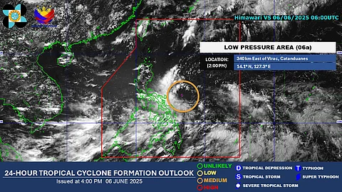
A low-pressure area (LPA) over the Philippine Sea is forecast to move northwest and may bring moderate to heavy rains over Luzon during the long weekend.
Once the LPA develops into a tropical depression, it will be named Auring — the first tropical cyclone of 2025.
As of 3 PM, the weather disturbance was spotted 340 kilometers east-northeast of Virac, Catanduanes.
PAGASA Weather Specialist John Manalo said in a phone interview that the LPA has a medium chance of developing into a tropical cyclone within the next 24 hours.
“It’s still uncertain if it will develop into a tropical cyclone, but since it’s moving northwestward, areas like Central Luzon and Metro Manila may be affected in the coming days, especially by the LPA’s trough,” Manalo said.
The state weather bureau raised the LPA’s chance of cyclone development from “low” to “medium” on Thursday.
Should it strengthen further, Manalo said it could reach tropical storm category, but emphasized that such a scenario remains uncertain.
Currently, the LPA’s trough — or its extended area of influence — is affecting the Bicol Region and the eastern portions of Visayas and Mindanao.
In the next 24 hours, rainfall between 50 to 100 millimeters is expected in Catanduanes, Albay, Sorsogon, Northern Samar, Eastern Samar, Antique, and Palawan due to the combined effects of the LPA and the southwest monsoon.
In Metro Manila, there is a high chance of rain over the weekend.
“Moderate to occasionally heavy rains are expected, but this forecast may still change depending on the LPA’s movement, propagation, and its interaction with the southwest monsoon,” Manalo added.
Apart from the LPA, the southwest monsoon is also bringing rains to Luzon and the western sections of Visayas and Mindanao.
