- NEWS
- the EDIT
- COMMENTARY
- BUSINESS
- LIFE
- SHOW
- ACTION
- GLOBAL GOALS
- SNAPS
- DYARYO TIRADA
- MORE

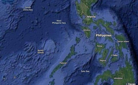
Malacañang on Monday welcomed the inclusion of the West Philippine Sea (WPS) on Google Maps, calling it a recognition of the country’s maritime rights.
In a press briefing, Palace Press Officer Undersecretary Atty. Claire Castro said the government is pleased with this “good news.”
“Definitely po, masaya po ito, nakakatuwa po ito. Masaya na makilala ang West Philippine Sea kahit na ang iba ay sinasabing gawa-gawa lamang daw ang West Philippine Sea (Definitely, this is something to be happy about — it's truly delightful. It's gratifying to see the West Philippine Sea recognized, even though some claim that the West Philippine Sea is merely fabricated),” Castro told reporters.
The National Maritime Council (NMC) also touted the labeling of the WPS on Google Maps as it “reflects the growing acceptance” of the Philippines’ assertion of its maritime rights.
Additionally, the Armed Forces of the Philippines (AFP) said the inclusion of the WPS in Google Maps affirmed international recognition of the country’s sovereign rights in the region.
The AFP, as defenders of national sovereignty, sees this development as a valuable contribution to truthful representation and public awareness of the country’s maritime rights in its exclusive economic zone.
The term "West Philippine Sea" was officially adopted in 2012 during the administration of then-President Benigno Aquino III to refer to parts of the South China Sea located on the western side of the Philippine archipelago.
