- NEWS
- the EDIT
- COMMENTARY
- BUSINESS
- LIFE
- SHOW
- ACTION
- GLOBAL GOALS
- SNAPS
- DYARYO TIRADA
- MORE

The weather state bureau PAGASA pointed out that the warm temperatures of the Pacific Ocean served as a haven for successive typhoons that caused widespread damage in the Philippines.
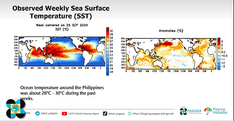
During the 178th Climate Forum, Kristel Anne Villasica, a weather specialist from PAGASA’s Climate Monitoring and Prediction Section, explained that the high water temperature in the ocean surrounding the Philippines acted as a breeding ground for strong tropical cyclones last month.
The National Oceanic and Atmospheric Administration (NOAA) stated that the ocean temperature must be at least 26.5°C at a depth of about 150 feet.
However, data showed that the ocean temperature in the waters around the Philippines was about 28°C to 30°C in recent weeks.
“There is an anomaly of 1°C to 2°C compared to the usual sea temperature. These warm ocean temperatures were the main reason that fueled the strong, consecutive cyclones,” Villasica said.
In nearly a month, six cyclones formed inside the Philippine Area of Responsibility (PAR), with five making direct landfall on Luzon’s landmass.
To recall, Severe Tropical Storm ‘Kristine’ stayed inside PAR from 21 to 25 October, Super Typhoon ‘Leon’ from 26 October to 31 October, Typhoon ‘Marce’ from 4 November to 8 November, Typhoon ‘Nika’ from 9 November to 12 November, Super Typhoon ‘Ofel’ from 12 November to 15 November, and the most recent Super Typhoon ‘Pepito’ from 14 November to 18 November.
Typhoon 'Kristine' made landfall in Isabela, while 'Leon' passed near Batanes. 'Marce' struck Northern Cagayan, and 'Nika' hit Aurora. 'Ofel' impacted mainland Cagayan, and 'Pepito' made landfall over both Catanduanes and Aurora.
Based on PAGASA’s Tropical Cyclone Threat Potential Forecast, there is a low chance of storm formation in the southern portion of the PAR during the week from 27 November to 3 December.
With the country still under La Niña Alert Watch, at least one to two cyclones are still expected before the year ends.
