- NEWS
- the EDIT
- COMMENTARY
- BUSINESS
- LIFE
- SHOW
- ACTION
- GLOBAL GOALS
- SNAPS
- DYARYO TIRADA
- MORE

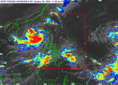
Severe tropical storm Kristine (international name Trami) is expected to loop back into the country after exiting the Philippine Area of Responsibility (PAR), state weather bureau PAGASA said Friday morning.
Based on its latest bulletin, ‘Kristine’ is projected to leave the PAR this afternoon to late evening.
However, possible recurvation in its path is seen starting this Sunday, 27 October, and Monday, 28 October.
PAGASA weather forecaster Chenel Dominguez said the recurving track of storm ‘Kristine’ is attributed to different factors such as the northeasterly wind flow, southwesterly wind flow, and the tropical depression outside PAR.
She also noted that the Fujiwhara effect, or the direct interaction between two storms, remains unlikely as both storms are at least 3,000 kilometers away. She added that for a Fujiwhara effect, both storms must be at least 1,500 kilometers apart.
‘Kristine’ is expected to intensify into a typhoon as it ventures into the West Philippine Sea (WPS); however, a possible weakening trend is expected early next week due to the effect of the northeasterly wind flow over the WPS.
Due to the storm’s wide radius of 730 kilometers, storm warning signals may remain in the western seaboard of the country even if its center is already outside of the PAR.
Meanwhile, the low-pressure area outside PAR has already merged with Tropical Depression ‘Kong-Rey’ which is currently spotted near Guam.
‘Kong-Rey’ is expected to enter the PAR this weekend and will be given the local name of ‘Leon.’
Based on the satellite imagery of Windy.com, the storm is expected to move across the Philippine Sea before heading to Taiwan or Japan in the coming days.
