- NEWS
- the EDIT
- COMMENTARY
- BUSINESS
- LIFE
- SHOW
- ACTION
- GLOBAL GOALS
- SNAPS
- DYARYO TIRADA
- MORE

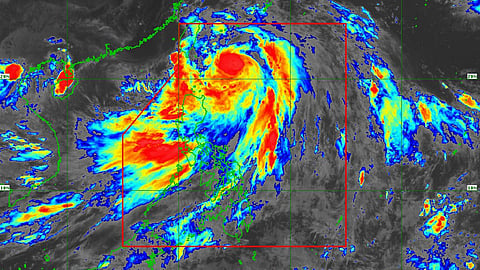
Typhoon Carina (international Gaemi), the third tropical storm to enter the country, has now intensified into a super typhoon, state weather bureau PAGASA said Wednesday afternoon.
Based on its monitoring at 4:00 p.m. Carina's center was estimated at 380 km north of Itbayat, Batanes, and has recorded maximum sustained winds of 185 kilometers per hour (km/h) near the center, gustiness of up to 230 km/h, and a central pressure of 930 hectoPascals (hPa).
As of writing, the typhoon moves northwestward at a 20 km/h pace and is projected to make landfall over Taiwan on Wednesday night.
PAGASA warned the public of strong to typhoon-force winds possibly extending outwards up to 700 km from the center.
Batanes remains under Signal No. 2
Tropical Cyclone Wind Signals (TCWS) No. 2 is still raised over Batanes, which may experience gale-force winds whose potential impacts are minor to moderate threats to life and property.
Meanwhile, TCWS No. 1 stays over the Babuyan Islands, the northern portion of mainland Cagayan (Claveria, Santa Praxedes, Sanchez-Mira, Pamplona, Abulug, Ballesteros, Aparri, Camalaniugan, Buguey, Santa Teresita, Santa Ana, Gonzaga), and the northern portion of Ilocos Norte (Burgos, Bangui, Pagudpud, Dumalneg, Adams).
Residents of these areas are warned of strong winds, which might cause minimal to minor threats to life and property.
Heavy Rainfall Outlook
The forecasted accumulated rainfall from Wednesday noon to Thursday noon is 50 to 100 millimeters for Batanes and the Babuyan Islands.
PAGASA noted that forecast rainfall is generally higher in elevated or mountainous portions, thus warning residents of these areas of possible flooding and rain-induced landslides, especially in locations that are highly or very susceptible to these hazards as identified in official hazard maps and in localities that have experienced considerable amounts of rainfall for the past several days.
Moreover, the southwest monsoon, or Habagat, enhanced by ‘Carina’ is expected to bring moderate to intense rainfall over various localities in the western portion of Luzon through Friday.
Track and Intensity Outlook
‘Carina’ has reached its peak intensity as a super typhoon before making landfall in Taiwan, according to PAGASA.
The weather agency said that its landfall in the said area will trigger a weakening trend for the rest of the forecast period.
Its latest track forecast also shows that the super typhoon will cross the rugged terrain of Taiwan and leave the Philippine Area of Responsibility (PAR) on Thursday morning.
Habagat, Butchoy, Carina affected population now 880K
The combined effects of Habagat, Tropical Depression Butchoy, which left the country last Saturday, and Super Typhoon Carina have now affected 882,861 people, or 183,464 families.
The latest situation report from the National Disaster Risk Reduction and Management Council (NDRRMC) showed that of the affected families, 8,230 are sheltered in 90 evacuation centers.
The region with the most tallied affected families is the Bangsamoro Autonomous Region in Muslim Mindanao (BARMM), with 339 affected barangays, affecting 567,448 people.
Eight fatalities were reported—four cases from the Zamboanga Peninsula and one each in Northern Mindanao, Davao Region, and BARMM.
Meanwhile, one case of death from the BARMM is still pending validation.
Two people were injured in Northern Mindanao. Likewise, one case of a missing person was reported in the same region.
Affected road sections climbed to 96, of which 18 are impassable. Meanwhile, 13 bridges are affected, of which, eight are impassable.
Damaged houses stood at 245 and were valued at over P2.5 million. These damages were reported in Mimaropa, Central Visayas, Zamboanga Peninsula, Northern Mindanao, Davao Region, Soccsksargen, Caraga, BARMM, and the Cordillera Region.
On the other hand, damage to infrastructure was estimated at P700,000, mainly reported from Northern Mindanao.
A state of calamity was declared in four municipalities, namely Pinamalayan in Oriental Mindoro, Jose Abad Santos (Trinidad) in Davao Oriental, and Kabacan and Pikit in Cotabato.
P156-worth of agri-losses
The latest assessment of the Department of Agriculture (DA) shows that local agri-production has suffered over P156 million in losses due to Habagat and Super Typhoon Carina.
Outputs affected were rice, corn, high-value crops, and livestock, affecting the livelihoods of 7,677 farmers.
Rice crops had the biggest losses, valued at P145.39 million from the volume loss of 856 metric tons.
According to the NDRRMC, P29 million worth of aid has already been extended to affected families.
DA, meanwhile, said it will be rolling out to the affected farmers bags of rice seeds, corn seeds, and vegetable seeds and providing cash aid through the Survival and Recovery Loan Program from the Agricultural Credit Policy Council, the Quick Response Fund for the rehabilitation of affected areas, and the deployment of available funds from the Philippine Crop Insurance Corporation.
