- NEWS
- the EDIT
- COMMENTARY
- BUSINESS
- LIFE
- SHOW
- ACTION
- GLOBAL GOALS
- SNAPS
- DYARYO TIRADA
- MORE

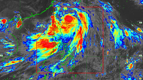
Typhoon Carina continues to intensify leaving the Batanes area under Tropical Cyclone Wind Signals (TCWS) No. 2 on Tuesday afternoon.
State weather bureau PAGASA's monitoring at 4:00 p.m. showed that Carina's center was estimated at 325 km east-northeast of Basco, Batanes.
Its intensity is recorded in maximum sustained winds of 159 kilometers per hour (km/h) near the center, gustiness of up to 185 km/h, and a central pressure of 960 hectoPascals (hPa).
A warning of strong to typhoon-force winds was raised, which extend outwards up to 540 km from the center.
Batanes under Signal No. 2
TCWS No. 2 is now raised in the Batanes, which may experience gale-force winds whose potential impacts are minor to moderate threats to life and property.
Meanwhile, TCWS No. 1 was hoisted over Cagayan, including the Babuyan Islands, the eastern portion of Isabela (Divilacan, Palanan, Maconacon, Dinapigue, Tumauini, Ilagan City, San Mariano, Cabagan, San Pablo, and Santa Maria), the northern portion of Apayao (Calanasan, Luna, Pudtol, Flora, Santa Marcela, and Kabugao), and the northern portion of Ilocos Norte (Pagudpud, Bangui, Adams, Dumalneg, Burgos, Vintar, Pasuquin, Bacarra, and Carasi).
Strong winds are expected in these areas, whose potential impacts are also minor to moderate threats to life and property.
Heavy rainfall outlook
The forecasted accumulated rainfall from Wednesday noon to Thursday noon is 100 to 200 millimeters (mm) for Batanes and 50 to 100 mm for the Babuyan Islands.
Forecast rainfall is generally higher in elevated or mountainous areas. The public is warned about possible flooding and rain-induced landslides, especially in areas that are highly or very susceptible to these hazards as identified in official hazard maps and in localities that have experienced considerable amounts of rainfall for the past several days.
The southwest monsoon, or Habagat, enhanced by ‘Carina’ is also seen to bring moderate to intense rainfall over various localities in the western portion of Luzon through Thursday.
Track and intensity outlook
‘Carina’ is projected to move generally north-northwestward on Tuesday night while gradually accelerating before turning northwestward on Wednesday.
Typhoon Carina is also projected to steadily intensify and may reach its peak intensity before its landfall over Taiwan due to a favorable environment, PAGASA said.
Rapid intensification within the forecast period is likely.
The typhoon is estimated to remain far from the Philippine landmass and leave the Philippine Area of Responsibility (PAR) on Thursday.
‘Carina’ is the third tropical storm to enter the PAR this year as a tropical depression Butchoy left the PAR on Saturday morning.
Carina, Butchoy, Habagat affected population nearly 900K; death toll at 8
The combined effects of Carina, Butchoy, and Habagat have affected 866,483 people, or 179,744 families, according to the National Disaster Risk Reduction and Management Council (NDRRMC).
In its latest situation report, NDRMMC said 7,738 families, or 33,645 persons, were served sheltered in 56 evacuation centers.
Eight people were confirmed dead. Of these, four are on the Zamboanga Peninsula and one each in Northern Mindanao, Davao Region, and BARMM.
Meanwhile, a case of death from the BARMM is still pending validation.
Two people were reported injured, while one missing person was reported in Northern Mindanao.
A total of 73 road sections and five bridges were affected.
Meantime, a total of 236 damaged houses are reported in Mimaropa, Central Visyas, Zamboanga Peninsula, Northern Mindanao, Davao Region, Soccsksargen, Caraga, and BARMM, amounting to P2.5 million.
Damage to infrastructure was valued at P700,000 while damage and losses to the agriculture sector were valued at over P8.7 million.
