- NEWS
- the EDIT
- COMMENTARY
- BUSINESS
- LIFE
- SHOW
- ACTION
- GLOBAL GOALS
- SNAPS
- DYARYO TIRADA
- MORE

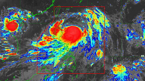
Severe tropical storm ‘Carina’ (international name Gaemi) has now intensified into a typhoon while moving over the Philippine Sea, state weather bureau PAGASA said on Monday afternoon.
Based on its latest monitoring, Carina's center was estimated at 420 km east of Tuguegarao City, Cagayan, and is moving north-northeastward slowly.
As of 5:00 PM, its intensity is maximum sustained winds of 120 kilometers per hour (km/h) near the center, gustiness of up to 150 km/h, and a central pressure of 980 hectoPascals (hPa).
PAGASA hence warned about strong typhoon-force winds possibly extending outwards up to 300 km from the center.
Signal No.1 hoisted
As of press time, some Luzon areas are under Tropical Cyclone Wind Signals No. 1, namely Batanes, the eastern portion of mainland Cagayan (Santa Ana, Gattaran, Baggao, Peñablanca, Lal-Lo, Gonzaga), including the eastern portion of the Babuyan Islands (Camiguin Is., Babuyan Is.), and the northeastern portion of Isabela (Divilacan, Palanan, Maconacon).
Residents of these areas are warned of possible strong winds whose potential impacts are minimal to minor threats to life and property.
Heavy rainfall outlook
The forecasted accumulated rainfall from Monday to Tuesday noon is 100 to 200 millimeters (mm) for the extreme northeastern portion of mainland Cagayan and 50 to 100 mm for the Babuyan Islands and the eastern portions of mainland Cagayan and Isabela.
From Tuesday noon to Wednesday noon, a rainfall of 100 to 200 mm is projected for Batanes. and 50 to 100 mm for the Babuyan Islands and the northeastern portion of mainland Cagayan.
Likewise, from Wednesday noon to Thursday noon, 50 to 100 mm of rainfall are seen in Batanes.
Forecast rainfall is generally higher in elevated or mountainous areas. The public is warned about possible flooding and rain-induced landslides, especially in areas that are highly or very susceptible to these hazards as identified in official hazard maps and in localities that have experienced considerable amounts of rainfall for the past several days.
Further, the southwest monsoon enhanced by ‘Carina’ will bring moderate to intense rainfall over various localities in the western portion of Luzon on Monday night through Wednesday.
Track and intensity outlook
PAGASA’s latest forecast shows ‘Carina’ will move generally northward from Monday until Tuesday while gradually accelerating before turning northwestward.
Typhoon Carina is also projected to steadily intensify over the next four days due to a favorable environment. Meantime, rapid intensification within the forecast period is likely.
‘Carina’ is estimated to remain far from the Philippine landmass and leave the Philippine Area of Responsibility (PAR) on Wednesday night or Thursday early morning.
‘Carina’ is the third tropical storm to enter the PAR this year as tropical depression (TD) Butchoy left the PAR on Saturday morning.
Last May, TD Aghon intensified into a tropical storm, making it the first tropical cyclone in the country for 2024. It left PAR with six fatalities, eight injuries, and damage to agriculture and infrastructure worth over P1 billion.
