- NEWS
- the EDIT
- COMMENTARY
- BUSINESS
- LIFE
- SHOW
- ACTION
- GLOBAL GOALS
- SNAPS
- DYARYO TIRADA
- MORE

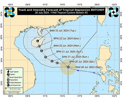
Tropical Depression “Butchoy” has left the Philippine Area of Responsibility (PAR), the Philippine Atmospheric, Geophysical and Astronomical Services Administration (Pagasa) said Saturday.
In its latest advisory, “Butchoy” was located 565 kilometers (km) west of Iba, Zambales, as of 10 a.m. Saturday.
PAGASA said “Butchoy” maintained its strength with maximum sustained winds of 55 kilometers per hour (kph) and gustiness reaching up to 70 kph. It was moving west-northwest at a slower pace of 10 kph.
The state weather bureau added that “Butchoy” is unlikely to directly affect the country.
PAGASA, however, stated that the southwest monsoon or habagat is still being enhanced by “Butchoy” and also by Tropical Depression “Carina” which will bring moderate to heavy rains over the western portion of Luzon over the next three days.
“Carina” was last located 510 kilometers southeast of Virac, Catanduanes.
“Carina” has a strength with maximum sustained winds of 55kph and gustiness reaching up to 70kph. It was forecast to move northwest at a pace of 30kph.
It was forecast to steadily intensify and reach tropical storm category within the next 12 to 24 hours.
Starting Monday, “Carina” will likely intensify further at a faster rate, eventually reaching typhoon category on Tuesday.
“Carina” maintained strength as it moved west northwest over the Philippine Sea. It is seen to exist PAR Wednesday morning.
