- NEWS
- the EDIT
- COMMENTARY
- BUSINESS
- LIFE
- SHOW
- ACTION
- GLOBAL GOALS
- SNAPS
- DYARYO TIRADA
- MORE

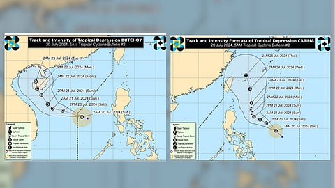
The Philippine Atmospheric, Geophysical and Astronomical Services Administration (PAGASA) reported that Tropical Depressions "Butchoy" and "Carina" are not expected to significantly impact the Philippines.
Tropical Depression "Butchoy" — As of 11:00 pm on 19 July 2024, the low-pressure area over the West Philippine Sea west of Batangas has developed into Tropical Depression "Butchoy." While Butchoy is not expected to directly affect the country within the next three days, the Southwest Monsoon it enhances may bring moderate to heavy rains over the western portion of Luzon during this period. Mariners are advised to exercise caution due to moderate to rough seas (1.0-2.0 meters) along the northern and western seaboards of Luzon. Butchoy is forecasted to move west northwestward until 20 July before turning north northwestward beginning on 21 July. It may exit the Philippine Area of Responsibility within 12 hours and is likely to make landfall over Hainan, China, by late Sunday or early Monday. While Butchoy is expected to reach tropical storm category by tomorrow, rapid weakening is anticipated after its landfall over Hainan.
Tropical Depression "Carina" — Similarly, as of 11:00 pm on 19 July 2024, the low-pressure area over the Philippine Sea has developed into Tropical Depression "Carina." Heavy rainfall directly caused by Carina is less likely over the next three days, although forecast changes may alter this outlook. Carina, along with the Southwest Monsoon enhanced by Butchoy, will result in moderate to heavy rains over the western portion of Luzon starting 21 July. Mariners should be cautious due to moderate seas (1.0-2.0 meters) along the eastern seaboard of Mindanao. Carina is expected to move northwestward until 21 July, decelerate and turn north northwestward on 22 July, and then accelerate northward over the Philippine Sea towards the Ryukyu archipelago from 23 July onwards. Carina is forecasted to reach tropical storm category by 21 July and may intensify to a typhoon by 23 July.
Source: PAGASA
