- HEADLINES
- NEWS
- PAGE THREE
- COMMENTARY
- BUSINESS
- LIFE
- ACTION
- GLOBAL GOALS
- SNAPS
- DYARYO TIRADA
- MORE
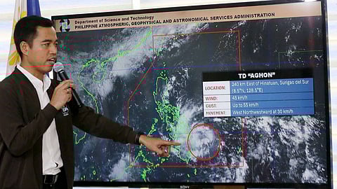
The state weather bureau on Saturday reported that more areas in Luzon are placed under Tropical Cyclone Wind Signal (TCWS) No. 1 as Tropical Depression "Aghon" continues to maintain its strength while moving northwestward over the Samar Sea.
In its latest weather bulletin, the Philippine Atmospheric, Geophysical and Astronomical Services Administration (PAGASA) said Aghon is forecast to move generally northwestward over the Samar Sea and cross the Bicol Peninsula between Saturday afternoon and Sunday early morning.
The center of the eye of Aghon was last seen over the coastal waters of Catbalogan City, Samar, moving northwestward at 30 kph, with maximum sustained winds of 55 kph near the center and gustiness of up to 70 kph.
Around Sunday afternoon, Aghon will begin its re-curvature towards the northeast.
The weather disturbance, as it moves over the Philippine Sea, is forecast to continuously intensify and may reach typhoon category on Tuesday next week.
PAGASA said as high as Wind Signal No. 2 may be hoisted during the passage of Aghon.
Meanwhile, TCWS No. 1 is hoisted in the following areas:
Luzon: The northern portion of Aurora (Casiguran, Dilasag), Polillo Islands; The southern portion of Quezon (Calauag, Guinayangan, Lopez, Buenavista, Catanauan, Mulanay, San Narciso, San Francisco, San Andres, Tagkawayan, Gumaca, Quezon, Alabat, Perez, Plaridel, Pitogo, Macalelon, General Luna, Atimonan, Unisan); The eastern portion of Romblon (Cajidiocan, Magdiwang, San Fernando); Camarines Norte; Camarines Sur; Catanduanes; Albay; Sorsogon; Masbate, including Burias and Ticao Islands.
Visayas: Northern Samar; Samar; Eastern Samar; Biliran; Leyte; Southern Leyte; The extreme northern portion of Cebu (San Remigio, Tabogon, City of Bogo, Medellin, Daanbantayan, Borbon), including Camotes and Bantayan Islands
Mindanao: Dinagat Islands
Meanwhile, PAGASA warns flooding and rain-induced landslides are possible, especially in areas that are highly or very highly susceptible to these hazards as identified in hazard maps and in localities that experienced considerable amounts of rainfall for the past several days.
Further, Aghon will bring rains with gusty winds over the Bicol Region, Quezon, and Eastern Visayas.
Metro Manila, Central Luzon, Mimaropa, Mindanao, Cagayan, Isabela, Quirino, Nueva Vizcaya, the rest of Calabarzon, and the rest of the Visayas will have cloudy skies with scattered rain showers and thunderstorms due to the trough of Aghon.
The Ilocos Region, the Cordilleras, and Batanes will have partly cloudy to cloudy skies with isolated rain showers or thunderstorms due to localized thunderstorms.
Aghon will also bring moderate to rough seas (1.5 to 3.5 m) over the coastal waters along the seaboards of the Bicol Region, the southern seaboard of Quezon, the eastern seaboard of Eastern Visayas, the western seaboard of Samar and Northern Samar, and the eastern seaboard of Caraga Region.
Hence, PAGASA reminded mariners of motor bancas and similarly-sized vessels to take precautionary measures while venturing out to sea and, if possible, avoid navigating in these conditions, especially if inexperienced or operating ill-equipped vessels.
PAGASA said Aghon may exit the Philippine area of responsibility (PAR) in no earlier than Tuesday.
