- NEWS
- the EDIT
- COMMENTARY
- BUSINESS
- LIFE
- SHOW
- ACTION
- GLOBAL GOALS
- SNAPS
- DYARYO TIRADA
- MORE

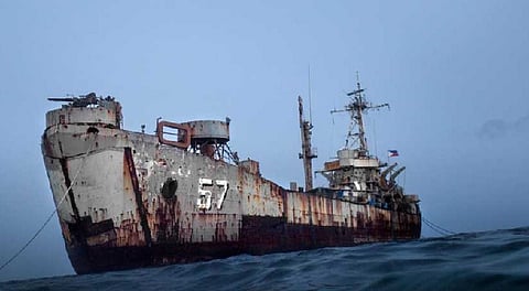
Retired Senior Associate Justice Antonio Carpio has debunked China's claims of sovereignty over some features of the West Philippine Sea, including Ayungin (Second Thomas) Shoal, Spratlys Island, and Bajo de Masinloc (Scarborough Shoal), saying it is "utterly false."
Carpio made the remark after the Chinese Foreign Ministry accused the Philippines of "intruding" in Ayungin and Scarborough shoals, saying that it was "China's territory since ancient times."
"Ayungin Shoal is not a territory as ruled by the arbitral tribunal in its award of 12 July 2016," Carpio was quoted as saying in a statement released by the Armed Forces of the Philippines Friday.
Ayungin Shoal is a low-tide elevation beyond the territorial sea of any high-tide feature, so "it falls within the exclusive economic zone of the Philippines," he pointed out.
Carpio said the Philippines has sovereign rights over the shoal since it is within 200 nautical miles from the archipelagic baselines of the country and beyond 200 nautical miles from the baselines of any other state.
"It is basic in international law that such a low-tide elevation is not a territory capable of being subject to sovereignty," he said.
China's ancient times
Carpio said all the ancient maps of China, as published in Beijing's Atlas of Ancient Maps in China, "show that the southernmost territory of China during all the Chinese dynasties was Hainan Island."
He said that when France occupied the Paracels in 1932, Beijing officially protested on the ground that the Paracels formed the "southernmost territory" of China.
Carpio noted that the Paracels are "more than 400 nautical miles from the Spratlys."
China officially published the China Handbook in 1943, which declared that the southernmost territory of China was Triton Island in the Paracels, he said.
Phl owns Spratlys
It was only in its revised 1947 China Handbook that the Chinese first claimed the Spratlys, "but at the same time, China admitted that the Spratlys were also claimed by the Philippines and the French in Indochina."
Carpio said Spratlys Island has appeared as part of Philippine territory since the 1734 Murillo Velarde map, the first official map of the Philippine territory during the Spanish regime.
"The 1808 and the 1875 Carta General del Archipielago Filipino, both official maps of the Philippine territory during the Spanish regime, show that the Spratlys were part of Philippine territory," he stressed.
The former Chief Justice said the United States adopted and reissued the 1875 Carta General del Archipielago Filipino four times, in 1898, 1900, 1901, and 1902.
In the leading 1928 Islas Palmas case, the United States submitted the 1875 Carta General del Archipielago Filipino as an official Spanish and American map of Philippine territory at the time of the signing of the 1898 Treaty of Paris.
China gravely mistaken
Carpio said that China had submitted to the Permanent Court of Arbitration in The Hague a position paper which stated that the Philippine territory was defined by three treaties — the 1898 Treaty of Paris, the 1900 Treaty of Washington, and the 1930 Treaty between the United Kingdom and the United States.
Under these three treaties, China claims that "all the island territories of the Philippines are found only within the 1898 Treaty of Paris lines."
