- HEADLINES
- NEWS
- PAGE THREE
- COMMENTARY
- BUSINESS
- LIFE
- ACTION
- GLOBAL GOALS
- SNAPS
- DYARYO TIRADA
- MORE

China's new map expanding its nine-dash line territorial claim in the South China Sea is undermining the peace and security in the Asia-Pacific Region, geopolitical analyst Marlon Villarin told Daily Tribune's sister publication Dyaryo Tirada over the weekend.
Appearing in the digital show "Hot Patatas," the University of Santo Tomas political science professor belittled Beijing's new "standard map" for 2023 as a mere fabrication that would not stand scrutiny against the so-called Velarde map.
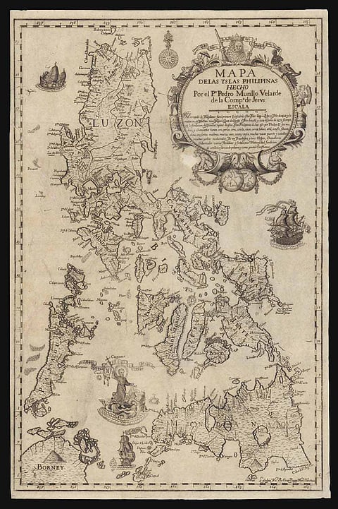
The Velarde map is one of the oldest maps in the world, the one that the Philippines used to stake its territorial claim in the West Philippine Sea before the Permanent Court of Arbitration at The Hague.
In 2016, the arbitral court affirmed that the Philippines holds rights over its exclusive economic zones in the WPS while dismissing China's nine-dash line claim to nearly the entire South China Sea for being without legal or historical basis.
"As things stand, they (Chinese) seemed to have fabricated (the nine-dash line claim). On the other hand, one of the oldest maps, the Velarde map, has helped us a lot," Villarin told Tirada editor Rose Novenario. "It showed that it (WPS) is part of our territory."
Discredited original
If China's nine-dash line map had been set aside by the arbitral court, it follows that its 10-dash line claim also has no basis, it being an expanded version of the discredited original, other political analysts have posited.
Drawn by Jesuit priest Father Pedro Murillo Velarde, the map was published in Manila in 1734 and was described as "the first and most important scientific map in the Philippines."
Titled "Mapa de Las Yslas Pilipinas Hecho Por el Pe. Pedro Murillo de Compa. De Jesus," the drawing has been instrumental, along with 270 other documents, in refuting China's claim that it owns nearly the entire SCS.
The WPS overlaps with the bigger SCS, where Chinese vessels, including from its navy and coast guard, had been harassing Filipino fishermen and Philippine-flagged ships.
Aside from the Philippines, India and Malaysia condemned China for expanding its claim in the South China Sea, where trillions of dollars' worth of trade passes each year, through the new map.
The United States has been conducting freedom of navigation air and sea patrols in the SCS to ensure the safe passage of commercial vessels in international waters, including those near the Taiwan Strait.
Claimants
The Philippines, China, Brunei, Malaysia, Vietnam and Taiwan have separate claims in the South China Sea where China's forces have been aggressively driving away other claimants.
Months back, a China Coast Guard vessel used water cannon on Philippine Coast Guard-led ships resupplying the BRP Sierra Madre, a World War 2-era ship that ran aground in the Ayungin Shoal to serve as a permanent outpost for Filipino troops.
Earlier, National Security Adviser Eduardo Año reiterated that the Philippine government does not recognize the 10-dash line or the nine-dash line claims of China.
The new Chinese map showed 10 dashes forming the letter U showing nearly the entire South China Sea as a territory of China.
Año stressed that the 2016 arbitral award was already final in debunking Beijing's nine-dash line assertion. The ruling also gave the Philippines "maritime entitlement" extending its economic zone, territorial waters, and continental shelf.
UNCLOS
"The recent inclusion by China of its 10-dash line in their map is a gross violation of the territorial integrity of the Philippines as protected by the United Nations Convention on the Laws of the Sea," Villarin said.
"It's an affront to the Philippine Constitution that safeguards the territorial integrity of our country. It is also a direct threat to the peace and security of the Asia-Pacific Region," he added.
Villarin stressed that nearly all of the countries in the region would be affected by China's claim, especially if it tries to enforce its "invention."
He recounted that in the 470-plus decisions made by the arbitral court, all of China's claims were dismissed for having no legal or historical legs to stand on.
