- NEWS
- the EDIT
- COMMENTARY
- BUSINESS
- LIFE
- SHOW
- ACTION
- GLOBAL GOALS
- SNAPS
- DYARYO TIRADA
- MORE

The estimated damage to infrastructure and farms in four regions has risen to P442.34 million as the rains continued yesterday, with three typhoons ringing the country.
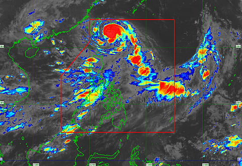
The weather remained critical because of the enhanced southwest monsoon or habagat and the effects of typhoon "Goring."
The Department of Public Works and Highways, or DPWH, said Saturday that of the total damage in the Cordillera, Ilocos, Cagayan Valley and MIMAROPA regions, P146.28 million involved damage to roads, P14.68 million to affected bridges, and P281.38 million to destroyed flood-control structures.
'Hanna' gathers strength
Meanwhile, typhoon 'Hanna' slightly intensified as it accelerated west-northwestward toward the sea east of Taiwan, while the enhanced southwest monsoon or habagat will bring heavy rains over the western portion of Luzon in the next three days, the Philippine Atmospheric, Geophysical and Astronomical Services Administration said Saturday.
PAGASA said the convergence of the southwest monsoon, enhanced by "Hanna" and two other typhoons near the country, namely, "Saola" (Goring), and severe tropical storm "Kirogi" are causing the adverse weather.
The National Disaster Risk Reduction and Management Council reported more than P421.19 million worth of damage in the agricultural sector, affecting some 10,196 farmers and fisherfolk.
Estimated damage to infrastructure amounting to P130.25 million was reported in Region 2, MIMAROPA, Region 6 and CAR.
The NDRRMC counted 502 houses damaged in the Ilocos region, Cagayan Valley, Calabarzon, MIMAROPA, Western Visayas and CAR, while 25 roads and nine bridges remained unpassable. Two areas in CALABARZON and Western Visayas still have no water supply.
Eighty-nine seaports have canceled operations in Cagayan Valley, CALABARZON, MIMAROPA and Western Visayas amid the continuing inclement weather.
Taiwan-bound anew
PAGASA said "Hanna" is forecast to move west-northwestward or westward while intensifying until it makes landfall on the east coast of southern Taiwan late on Sunday. "Hanna" will considerably weaken after crossing the rugged land mass of Taiwan.
PAGASA said "Hanna" will exit the Philippine area of responsibility and emerge over the Taiwan Strait around Monday morning or afternoon.
Outside the PAR, the weather disturbance is forecast to move erratically and may even become slow-moving or almost stationary over the Taiwan Strait while continuously weakening due to land interaction and an increasingly unfavorable environment.
