- NEWS
- the EDIT
- COMMENTARY
- BUSINESS
- LIFE
- SHOW
- ACTION
- GLOBAL GOALS
- SNAPS
- DYARYO TIRADA
- MORE
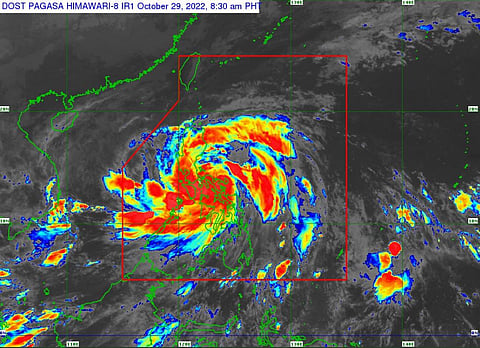
The weather bureau's latest bulletin on 29 October said Severe Tropical Storm "Paeng" crossed the Bondoc Peninsula in Southern Quezon, after making landfall in Buenavista in Quezon at 6 am.
The storm's center was estimated over the coastal waters of Catanauan, Quezon.
It is moving west northwestward at 30 km/h, with maximum sustained winds of 95 km/h near the center and gustiness of up to 160 km/h
Its forecast position:
Oct 29, 2022 05:00 PM – In the vicinity of Binangonan, Rizal (Laguna de Bay)
Oct 30, 2022 05:00 AM – Over the coastal waters of Palauig, Zambales
Oct 30, 2022 05:00 PM – 275 km West of Dagupan City, Pangasinan
Oct 31, 2022 05:00 AM – 355 km West of Baguio City
Oct 31, 2022 05:00 PM – 365 km West of Sinait, Ilocos Sur (Outside the PAR)
Nov 01, 2022 05:00 AM – 390 km West of Laoag City, Ilocos Norte (Outside the PAR)
Nov 02, 2022 05:00 AM – 390 km West of Laoag City, Ilocos Norte (Outside the PAR)
Nov 03, 2022 05:00 AM – 735 km West of Itbayat, Batanes (Outside the PAR)
