- NEWS
- the EDIT
- COMMENTARY
- BUSINESS
- LIFE
- SHOW
- ACTION
- GLOBAL GOALS
- SNAPS
- DYARYO TIRADA
- MORE

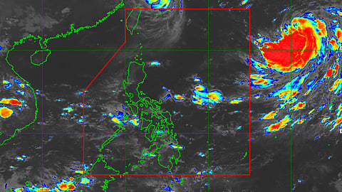
The Philippine Atmospheric, Geophysical and Astronomical Services Administration is monitoring the movement of a tropical depression which may enter the Philippine area of responsibility by Thursday.
The state weather bureau said that the tropical depression is forecast to track slowly northeastward and may become almost stationary within 36 hours, before sharply turning northwestward or west-northwestward on Thursday while accelerating.
The tropical cyclone will be named "Josie" once it enters the PAR and PAGASA said that it will likely intensify into a tropical storm within 24 hours.
"By Thursday, improving environmental conditions will enable the tropical cyclone to intensify at a relatively faster rate. Current forecast scenario shows that this tropical cyclone will enter the PAR as a typhoon," PAGASA said.
It added that "Josie" remains far from the Philippine landmass and will not directly affect the weather condition in the country.
It was last tracked over 1,740 km East of Extreme Northern Luzon outside the PAR and packs a maximum sustained winds of 55 kilometers per hour near the center, with gustiness of up to 70 kph and a central pressure of 998 hPa.
However, "Josie" may enhance the southwest monsoon within the forecast period and is expected to bring rains over the western sections of Southern Luzon and Visayas beginning Wednesday or Thursday.
The public as well as the disaster risk reduction and management offices concerned are advised to continue monitoring for updates related to tropical cyclone "Josie."
Meanwhile, typhoon "Inday" exits PAR on Wednesday, but the gale warning remains in effect for the seaboards of Batanes and Babuyan Islands.
Gusty conditions reaching strong-to-gale-force strength will continue to be experienced over Extreme Northern Luzon today and tomorrow due to the channeling of the typhoon circulation in the Luzon Strait.
