- NEWS
- the EDIT
- COMMENTARY
- BUSINESS
- LIFE
- SHOW
- ACTION
- GLOBAL GOALS
- SNAPS
- DYARYO TIRADA
- MORE

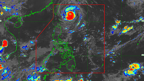
Severe Tropical Storm "Inday" (international name: Muifa) has intensified into a typhoon as it moved northwestward over the Philippine Sea.
In its latest weather bulletin, the Philippine Atmospheric, Geophysical and Astronomical Services Administration said "Inday" will not directly affect the country but could bring heavy rains over the eastern section of Southern Luzon and the western portion of Central Luzon throughout the forecast period.
"Inday" now packs maximum sustained winds of 110 kilometers per hour near the center and gustiness of up to 135 kph.
The typhoon was last spotted 430 kilometers east of Basco, Batanes, and was moving west-northwestward at 20 kph.
PAGASA said "Inday" may enhance the southwest monsoon or habagat that could bring rains over the western sections of Southern Luzon and the Visayas.
There is a possibility of raising tropical cyclone wind signals over parts of extreme Northern Luzon.
PAGASA said "Inday" may bring moderate to rough seas over the seaboards of Batanes (2.0 to 4.0 meter) and Babuyan Islands (1.5 to 3.0 meter) until Sunday. These conditions may be risky for those using small seacrafts.
Mariners are advised to monitor for updates, take precautionary measures when venturing out to sea and, if possible, avoid navigating in these conditions during the said period.
The typhoon is forecast to move generally northwestward over the Philippine sea through Monday as it tracks towards the sea east of Taiwan.
It may exit the Philippine Area of Responsibility and pass close to the Miyako or Yaeyama Islands by late Tuesday or early Wednesday next week.
However, the slightly cooler waters east of Taiwan and the forecast slow-down period over this sea area may result in a weakening trend beginning on Monday or Tuesday.
