- NEWS
- the EDIT
- COMMENTARY
- BUSINESS
- LIFE
- SHOW
- ACTION
- GLOBAL GOALS
- SNAPS
- DYARYO TIRADA
- MORE

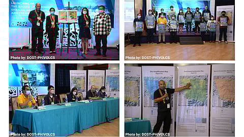
BAGUIO CITY — The Department of Science and Technology and the local government here recently launched the "Baguio City Ground Shaking Hazard Maps" in coordination with the Philippine Institute of Volcanology and Seismology.
The project is considered as a significant milestone for being the country's pilot study on seismic investigation of subsurface properties using methodologies applicable to the mountainous terrain of the City of Pines.
DoST Cordillera regional director Nancy Bantog stressed that the project is one of the outputs of the "Passive Seismic Stratigraphy of Irregular Topography" program implemented by the DoST and the city government of Baguio.
BCGSHM is a compilation of maps that provides information on the levels of ground motion and site response during strong earthquakes bases on the characteristics of the underlying soil and rock layers and the effects of specific topography like Baguio City.
Bantog said that this will definitely help the local government units improve their development plan towards an earthquake-resilient Baguio City, stressing that the hazard maps can help in the rapid urbanization of the city once it is integrated with the city's policies and the City's Land Use Plan (CLUP).
Phivolcs said that Baguio City — as a highly urbanized city ranked — 19th in the whole country when it comes to experiencing strong earthquakes in the past because of its proximity to active faults.
The most devastating earthquake that hit Baguio including nearby provinces and regions in North Luzon was in 16 July 1990 when a magnitude 7.8 earthquake hit Nueva Ecija which was caused by the movements along the Philippine fault and the Digdig fault within the country's fault system.
To recall, the northwestern part of Luzon was jolted by a 7.0 magnitude earthquake with the epicenter at Lagangilang, Abra on 27 July and Baguio City was also affected by the temblor.
