- NEWS
- the EDIT
- COMMENTARY
- BUSINESS
- LIFE
- SHOW
- ACTION
- GLOBAL GOALS
- SNAPS
- DYARYO TIRADA
- MORE

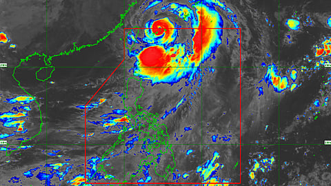
The combined effect of the southwest monsoon and typhoon "Henry" (Hinnamnor) will bring rains over the northern part of the country.
In its latest weather bulletin, the Philippine Atmospheric, Geophysical and Astronomical Services Administration said moderate to heavy rains with at times intense rains will prevail in Metro Manila, Ilocos region, Cordillera Administrative Region, Zambales and Bataan while light to moderate with at times heavy rains will be experienced over the rest of Central Luzon, CALABARZON, Cagayan Valley, Isabela, Quirino and Nueva Viscaya.
People are warned against scattered flooding and rain-induced landslides under these weather conditions, particularly in hazard-prone areas.
Northward-bound
Meanwhile, "Henry" accelerated northward over the sea east of Taiwan and it is forecast to exit the Philippine Area of Responsibility either Saturday night or early Sunday morning.
PAGASA said "Henry" was last tracked over 445 kilometers northeast of Itbayat, Batanes, and packs a maximum sustained winds of 150 km per hour near the center with gustiness of up to 185 kph.
"Henry" will possibly bring moderate to heavy damage to structures and vegetation due to its destructive storm-force winds.
Tropical Cyclone Wind Signal No. 2 is still hoisted over Batanes, while Signal No. 1 is up over Babuyan Islands and the northeastern portion of mainland Cagayan.
Sunset was recorded 6:07 p.m. on Saturday while sunrise will be at 5:44 a.m. on Sunday.
